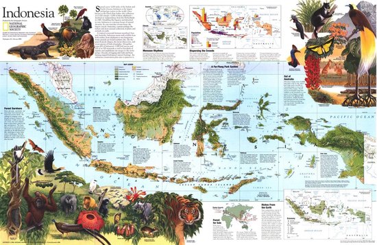
National Geographic: Indonesia Theme 1996 - Historic Wall Map Series - 31 x 20.25 inches - Paper Rolled
Spread across 3,000 miles of the Indian and Pacific Oceans, Indonesia is the largest archipelago nation in the world. Once known as the Dutch East Indies, this collection of 17,000 islands - 3,000 of them inhabited - declared its independence from the Netherlands in 1945. A treasure house of natural diversity, its vast stretches of rainforest - the largest outside Amazonia - contains perhaps the richest and most unusual collection of plants and animals on earth. Published in February 1996 as half of a two-map set with a political map of the country, this unique map of Indonesia accompanied the article "Irian Jaya: Indonesia's Wild Side."
Explore this fascinating land of unique animal species, the world's largest flower, and butterflies with foot-wide wingspans with this beautiful and educational map of Indonesia. Vibrantly colored illustrations bring the diverse ecosystems to life. This map offers an engaging look into the geological and ecological diversity of regions from Sumatra and Java to Wallacea and Moluccas.
Additional maps on monsoon rhythms, rainfall, population density, economy, and natural resource exports add dimension to this informative product. Drawn in the Mercator projection, which represents any course of constant bearing as a straight segment, ideal for regions around the equator.
This map is truly a vibrant and unique conversation piece. It makes a fine companion to the political map of Indonesia with which it was published.
Printed on high quality thick paper strong enough for display on your wall.
| Auteur | | |
| Taal | | |
| Type | | |
| Categorie | | Reizen |


